
|
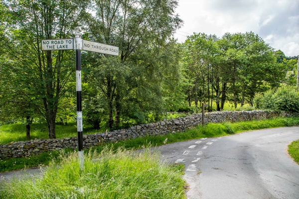
Start from near the Kirkstile Inn
From the No road to the lake/No through road signpost near the Kirkstile Inn in Loweswater, follow the 'No Through Road' lane past Kirkgate Farm and between stone walls towards Melbreak.
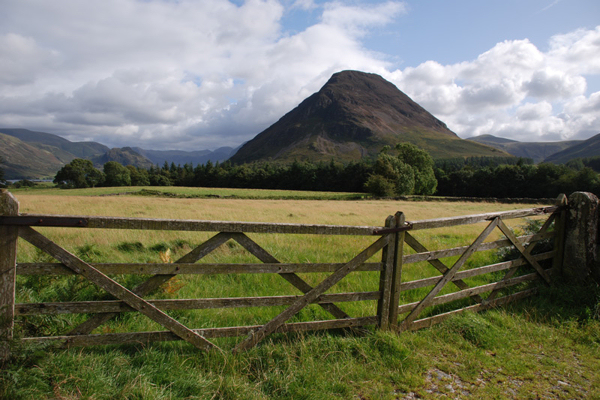
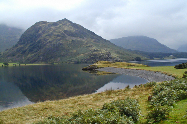
Melbreak from below the Kirkstile Inn
From along this track you will get a good view of Melbreak ahead.
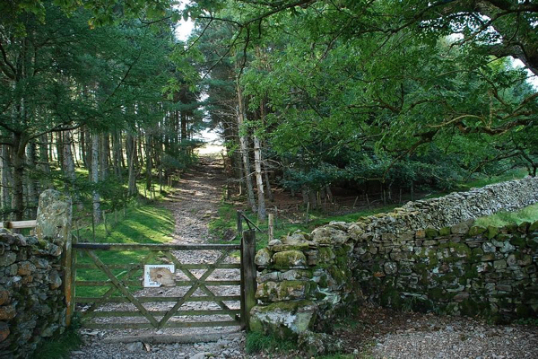
Turn left through a wooden gate
You will reach a gate on your left into trees. Go through the gate and along the firebreak into the open again. From here head up over grass toward Melbreak and the base of a tongue of screes.
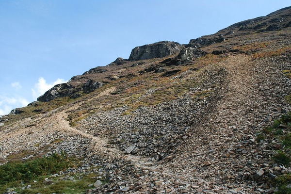
Zigzag up the screes
The path now zigzags to the left or right of the worst of the scree to reach a gateway in the rock. This is the toughest section of the walk and just has to be done if you want the views from the top!
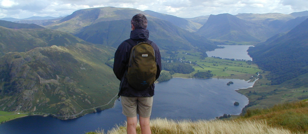
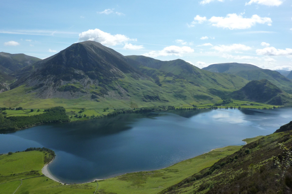
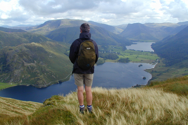
Surprise View over Crummock Water
However there is a point you can detour left from your path to Surprise View. Here your efforts so far are rewarded with a superb view over Crummock Water with Grasmoor, Whiteless Pike, and Rannerdale Knotts in view left to right on the far shore.
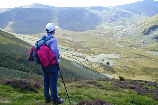
Looking out over Mosedale
Continue through the gateway in the rock, then turn left, following the path as it climbs over knolls, then flattens out through heather towards the North Top cairns (509m). There is a superb view over Mosedale to the west of Melbreak from above the scree slope.
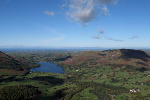
Reaching the first summit!
Reaching the first summit (North Top 509m) you are rewarded with fabulous views north and north west towards the Solway Firth and the Scottish hills. From here the marginally higher South Top of Melbreak is approximately half a mile away SSE along an obvious but often boggy path.
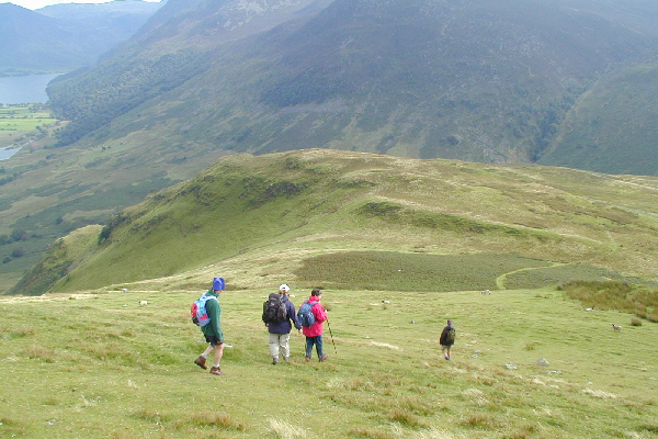
Walk the ridge to South Top
South Top (512m) offers the most glorious views of all - over Crummock Water and Buttermere and all the surrounding fells. This is definitely the view that makes the effort worthwhile!
Descent off the end of Melbreak
To descend from here, follow the path as it continues south fairly steeply down over grass to Scale Knott, then down again to cross the fence at a point where many people have crossed (dogs can go underneath).
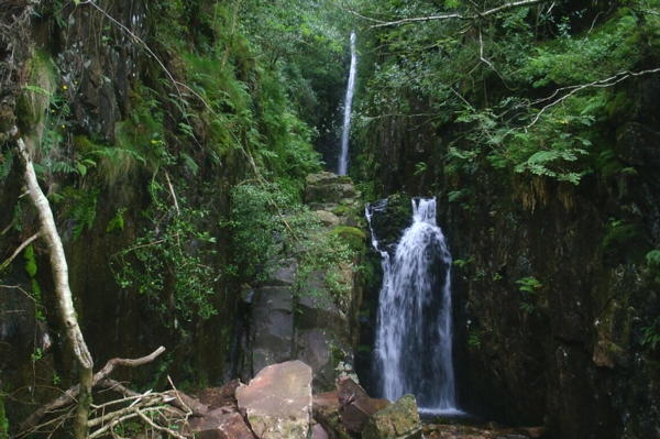
Detour to Scale Force waterfall
Continuing on down from the fence, the path reaches Black Beck which you can cross on stepping stones, then make your way up to a stile to reach Scale Force (waterfall) - well worth the detour especially after rain (dogs can get through the fence at the stile). Scale Force almost hidden in a cleft on the far side of Scale Beck - the waterfall with the longest single drop in the Lakes.
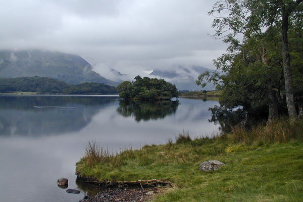
Take the path back beside Crummock Water
After enjoying the waterfall, walk down along a path that follows the left hand side of Scale Beck, only crossing a footbridge when you reach Black Beck in the valley bottom. Bear right after the bridge towards the shore of Crummock Water, then left along the shore.
Back along the shore, then lanes
There is now a lovely path that follows the lake shore back towards your start, with superb views across the water to Rannerdale Knotts and Grasmoor - or back towards the Buttermere fells. At the far end of the lake before the shore curves right there is a wall heading away from the shore. Bear left here to join the upper path through Green Wood with the wall on your right. Continue ahead and largely on the level past High Park to a gate into a lane, and follow this lane to Park Bridge, forking left at the junction beyond to regain the signpost near the Kirkstile Inn - and a well-earned glass of something refreshing! |
||||||||||||
|
|
|||||||||||||
Intermediate walk over Melbreak
Melbreak is the striking fell that lies on the west side of Crummock Water with fabulous views over the whole of the Vale of Lorton. Try and park at the phone box in Loweswater, or next to Church Bridge near the Kirkstile Inn, (otherwise there is a proper car park at Maggie's Bridge). The walk starts from the No Through Road signpost near the Kirkstile Inn, climbs to the top of Melbreak (spelt Mellbreak on OS maps) to continue along its top, then down to Scale Force waterfall before returning beside Crummock Water.
Melbreak is the striking fell that lies on the west side of Crummock Water with fabulous views over the whole of the Vale of Lorton. Try and park at the phone box in Loweswater, or next to Church Bridge near the Kirkstile Inn, (otherwise there is a proper car park at Maggie's Bridge). The walk starts from the No Through Road signpost near the Kirkstile Inn, climbs to the top of Melbreak (spelt Mellbreak on OS maps) to continue along its top, then down to Scale Force waterfall before returning beside Crummock Water.
- 6 miles in length
- 650 metres of ascent & descent
- Ascent is steep, largely on a path through scree
- Descent less steep and mostly on grass
|
|
Start from near the Kirkstile Inn
From the No road to the lake/No through road signpost near the Kirkstile Inn in Loweswater, follow the 'No Through Road' lane past Kirkgate Farm and between stone walls towards Melbreak.
Melbreak from below the Kirkstile Inn
From along this track you will get a good view of Melbreak ahead.
Turn left through a wooden gate
You will reach a gate on your left into trees. Go through the gate and along the firebreak into the open again. From here head up over grass toward Melbreak and the base of a tongue of screes.
Zigzag up the screes
The path now zigzags to the left or right of the worst of the scree to reach a gateway in the rock. This is the toughest section of the walk and just has to be done if you want the views from the top!
Surprise View over Crummock Water
However there is a point you can detour left from your path to Surprise View. Here your efforts so far are rewarded with a superb view over Crummock Water with Grasmoor, Whiteless Pike, and Rannerdale Knotts in view left to right on the far shore.
Looking out over Mosedale
Continue through the gateway in the rock, then turn left, following the path as it climbs over knolls, then flattens out through heather towards the North Top cairns (509m). There is a superb view over Mosedale to the west of Melbreak from above the scree slope.
Reaching the first summit!
Reaching the first summit (North Top 509m) you are rewarded with fabulous views north and north west towards the Solway Firth and the Scottish hills. From here the marginally higher South Top of Melbreak is approximately half a mile away SSE along an obvious but often boggy path.
Walk the ridge to South Top
South Top (512m) offers the most glorious views of all - over Crummock Water and Buttermere and all the surrounding fells. This is definitely the view that makes the effort worthwhile!
Descent off the end of Melbreak
To descend from here, follow the path as it continues south fairly steeply down over grass to Scale Knott, then down again to cross the fence at a point where many people have crossed (dogs can go underneath).
Detour to Scale Force waterfall
Continuing on down from the fence, the path reaches Black Beck which you can cross on stepping stones, then make your way up to a stile to reach Scale Force (waterfall) - well worth the detour especially after rain (dogs can get through the fence at the stile).
Scale Force almost hidden in a cleft on the far side of Scale Beck - the waterfall with the longest single drop in the Lakes.
Take the path back beside Crummock Water
After enjoying the waterfall, walk down along a path that follows the left hand side of Scale Beck, only crossing a footbridge when you reach Black Beck in the valley bottom. Bear right after the bridge towards the shore of Crummock Water, then left along the shore.
Back along the shore, then lanes
There is now a lovely path that follows the lake shore back towards your start, with superb views across the water to Rannerdale Knotts and Grasmoor - or back towards the Buttermere fells.
At the far end of the lake before the shore curves right there is a wall heading away from the shore. Bear left here to join the upper path through Green Wood with the wall on your right. Continue ahead and largely on the level past High Park to a gate into a lane, and follow this lane to Park Bridge, forking left at the junction beyond to regain the signpost near the Kirkstile Inn - and a well-earned glass of something refreshing!