
|
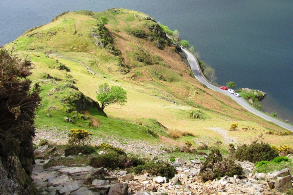
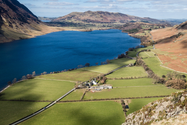
Setting off up to the saddle of Hause Point
For the short version of this walk, park if you can at the little NT car park at Hause Point (just in view in this photo that was taken from a little further back up the road). From the car park take the path that ascends straight up the hill towards the saddle in view above.
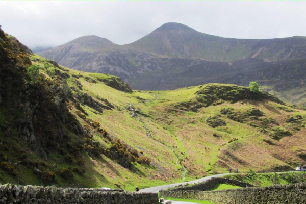
From the saddle turn left up the slope
(You can see the saddle in this photo looking down from above). Just beyond the saddle there is a choice of paths. Ignore the one going straight ahead, and instead keep left and uphill, then left again onto a recently rebuilt path which is stepped for quite a distance up through a gap in the crags. This is the steepest section of this route, but the views whenever you stop for a breather are astounding!
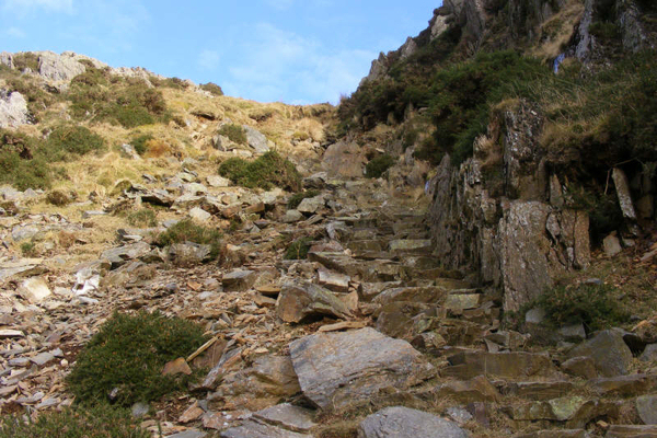
Keep tight against the crag to find the stepped path
This next photo shows the stepped path leading up through the crags. After this the way is gentler and mostly on grass to the summit cairn.
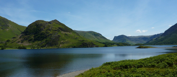
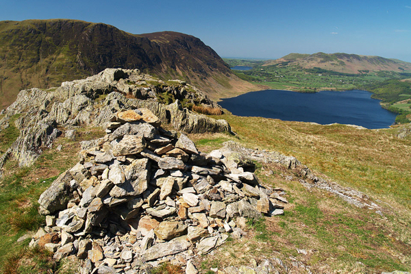
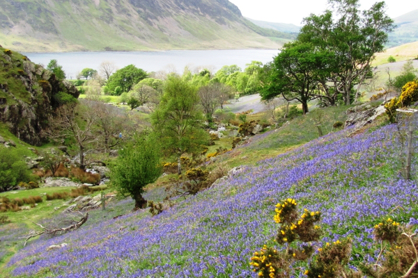
Stop for the view
The view of Crummock Water is stunning whenever you need to catch your breath! You can just see Loweswater beyond. After the stepped path through the crags the way is gentler and mostly on grass to the summit cairn.
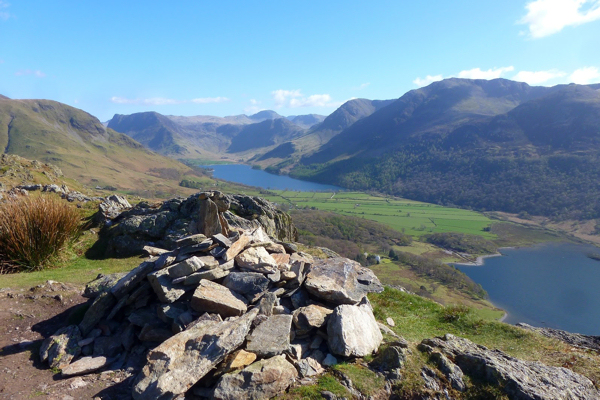
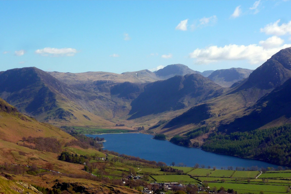
Reaching the summit!
From the summit you can see Crummock Water with Loweswater beyond, and Melbreak rising above the opposite shore... In the other direction will be Buttermere surrounded by all the Buttermere fells - Robinson, Fleetwith Pike, Haystacks, and the High Stile ridge. What a treat!
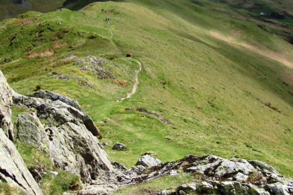
From the summit take the path along the ridge
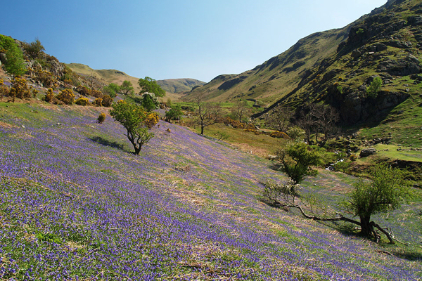
From the summit you take the path that heads south east and after an initial descent it is mostly on the level along the ridge called Low Bank. Looking off to the left you will sometimes be able to look down into Rannerdale below and what will be your descending path. In May there will be a haze of bluebells on the slopes below. The views of Buttermere only get better as you walk along the ridge. You will see Fleetwith Pike and Haystacks at the head of the valley - and Great Gable in the distance. At the end of the ridge keep left, then turn sharp left down into Rannerdale.
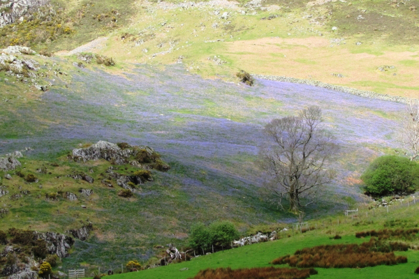
Turn left down into Rannerdale from the saddle
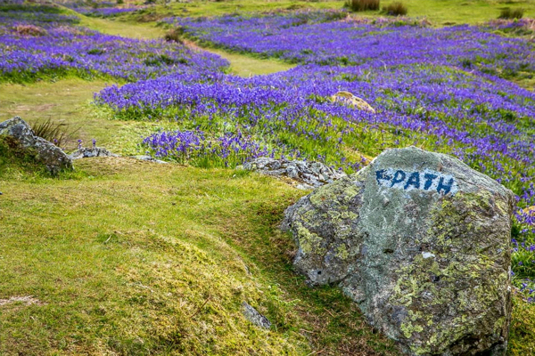
The path down into Rannerdale descends gently, and in May you will be walking through bluebells. However Rannerdale is delightful at any time of year, and always there is a stunning view of Crummock Water ahead. Turning around to look up Rannerdale to the saddle above the bluebells, with Robinson just peeping into view above the curve of the saddle.
Getting back to your car...
Depending on which side of the beck your path has taken you may need to cross the footbridge near the foot of the crags to get back to you car (past this boulder and through a gate beside a wall). If instead, you parked at Lanthwaite Green car park, you would keep to the right of the stream and continue ahead till your path regains the B5289 and so back to your car park. Alternatively, you can cross the road to walk back along the Crummock Water shore and through the woods. This stunning bluebell photo is by Andrew Locking, and you can see many more photos of this walk on his excellent walks website: in January, or in May. |
||||||||||||
|
|
|||||||||||||
A ramble on Rannerdale Knotts
Rannerdale Knotts is the striking low ridge overlooking Crummock Water from its south east shore. Though pretty steep to begin with, this uphill section takes a relatively easy stepped path to the summit which has wonderful views and truly rewards the effort. From there the rest of the walk is gentle and if done in May will finish through the Rannerdale bluebells.
This walk can be endlessly varied. You can shorten or lengthen it depending on where you park; you can make it easier by sticking to the Rannerdale valley for both your ascent and descent; or my favourite variation is to include a loop via Buttermere village for tea and cake, returning along the beck to the head of Crummock Water. Look at an OS map of the area to see all the possibilities!
- 3 or 8 miles in length
- 300 meters of ascent and descent
- Ascent is steep - on grass or stone-laid steps
- Descent is gentle
|
|
Setting off up to the saddle of Hause Point
For the short version of this walk, park if you can at the little NT car park at Hause Point (just in view in this photo that was taken from a little further back up the road). From the car park take the path that ascends straight up the hill towards the saddle in view above.
From the saddle turn left up the slope
(You can see the saddle in this photo looking down from above). Just beyond the saddle there is a choice of paths. Ignore the one going straight ahead, and instead keep left and uphill, then left again onto a recently rebuilt path which is stepped for quite a distance up through a gap in the crags. This is the steepest section of this route, but the views whenever you stop for a breather are astounding!
Keep tight against the crag to find the stepped path
This next photo shows the stepped path leading up through the crags. After this the way is gentler and mostly on grass to the summit cairn.
Stop for the view
The view of Crummock Water is stunning whenever you need to catch your breath! You can just see Loweswater beyond. After the stepped path through the crags the way is gentler and mostly on grass to the summit cairn.
Reaching the summit!
From the summit you can see Crummock Water with Loweswater beyond, and Melbreak rising above the opposite shore...
In the other direction will be Buttermere surrounded by all the Buttermere fells - Robinson, Fleetwith Pike, Haystacks, and the High Stile ridge. What a treat!
From the summit take the path along the ridge
From the summit you take the path that heads south east and after an initial descent it is mostly on the level along the ridge called Low Bank.
Looking off to the left you will sometimes be able to look down into Rannerdale below and what will be your descending path. In May there will be a haze of bluebells on the slopes below.
The views of Buttermere only get better as you walk along the ridge. You will see Fleetwith Pike and Haystacks at the head of the valley - and Great Gable in the distance. At the end of the ridge keep left, then turn sharp left down into Rannerdale.
Turn left down into Rannerdale from the saddle
The path down into Rannerdale descends gently, and in May you will be walking through bluebells. However Rannerdale is delightful at any time of year, and always there is a stunning view of Crummock Water ahead.
Turning around to look up Rannerdale to the saddle above the bluebells, with Robinson just peeping into view above the curve of the saddle.
Getting back to your car...
Depending on which side of the beck your path has taken you may need to cross the footbridge near the foot of the crags to get back to you car (past this boulder and through a gate beside a wall).
If instead, you parked at Lanthwaite Green car park, you would keep to the right of the stream and continue ahead till your path regains the B5289 and so back to your car park. Alternatively, you can cross the road to walk back along the Crummock Water shore and through the woods.
This stunning bluebell photo is by Andrew Locking, and you can see many more photos of this walk on his excellent walks website: in January, or in May.